
World Hydrography Day
#WorldHydrographyDay (WHD) is celebrated on 21 June and World Hydrography Day is celebrated to raise awareness on the importance of hydrography in improving our knowledge and understanding of the seas and oceans. This write up is to provide essential knowledge on this subject for readers of Bangbox Online.
World Hydrography Day
Hydrography is the branch of applied sciences which deals with the measurement and description of the physical features of oceans, seas, coastal areas, lakes and rivers, as well as with the prediction of their change over time, for the primary purpose of safety of navigation and in support of all other marine activities. Hydrography will include shore features, natural and manmade, lights and towers that will aid in fixing a ship's position, as well as the physical aspects of the sea and seabed. Hydrography of streams includes information on the stream bed, flows, water quality and surrounding land.
The origins of hydrography lay in the making of charts to aid navigation, by individual mariners as they navigated into new waters. These were usually the private property, even closely held secrets, of individuals who used them for commercial or military advantage. Major purpose of hydrographic surveying is to obtain data necessary for preparing nautical charts, which show water depths, navigation channels, structures (such as piers), breakwaters, and so on and which are used by mariners.
#WorldHydrographyDay (WHD) is celebrated on 21 June and World Hydrography Day is celebrated to raise awareness on the importance of hydrography in improving our knowledge and understanding of the seas and oceans. It was established in 2006, under a United Nations resolution by the International Hydrographic Organization (IHO). The theme chosen by International Hydrographic Organization (IHO) for WHD-24 is "Hydrographic Information Enhancing Safety, Efficiency, and Sustainability in Marine Activities," which aptly underscores the criticality of hydrographic services in contemporary #maritime affairs.
Annual celebration of this day emphasizes importance of #hydrography as it underpins almost every activity associated with the sea including safety of navigation, security and defence. environmental protection, ports/ harbour construction, coastal zone/ disaster management and maritime boundary delimitation. The objective of hydrography is to collect and record information about the physical features of water bodies (oceans, seas, lakes, …). Hydrographers measure the water depth and search for all types of submerged ridges, banks, wrecks, … rising from the bed of those water bodies.
Types of hydrographs include: Stream discharge hydrographs. Stream stage hydrographs. Precipitation hydrographs. Hydrographs or some elements of them, such as peak rates, are used in the planning and design of water control structures. They are also used to show the hydrologic effects of existing or proposed watershed projects and land use changes. Hydrographs show the rate of water flow over time for a river or stream. They are used to analyze flooding events and predict discharge patterns. A hydrograph displays discharge on the y-axis and time on the x-axis. Key features include the base flow, peak flow, time to peak, recession limb, and basin lag time.
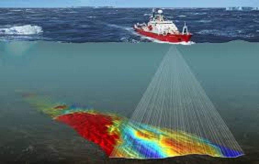
Hydrographic survey is the science of measurement and description of features which affect maritime navigation, marine construction, dredging, offshore wind farms, offshore oil exploration and drilling and related activities. By mapping out water depth, the shape of the seafloor and coastline, the location of possible obstructions and physical features of water bodies, hydrography helps to keep our maritime transportation system moving safely and efficiently. Hydrographic surveys deal with the mapping of large water bodies. Hydrographic surveys deal with the mapping of large water bodies. It needs involvement of many activities like maintenance of Port and Harbor, Coastal area management and offshore resource development.
Equipment and Applications for Hydrographic Survey:-
Sonar and Echo Sounders. Used for acoustic hydrographic surveying, sonar technology measures the reflection of acoustic pulses in order to construct an image of the surveyed area. ...
Depth Sensors and Underwater Altimeters. ...
Profiling Floats. ...
Tethered Boats. ...
Bathymetric LiDAR.
Message of CNS of Pakistan Navy on #WorldHydrographyDay
Following has been added from message of CNS of Pakistan Navy on #WorldHydrographyDay, as reflected at link https://www.facebook.com/DgprNavy
#Pakistan is blessed with over 1000 kms of coastline along with 290,000 Sq kms of sea area within its EEZ (Exclusive Economic Zone) and Continental Shelf (CS). Pakistan like other coastal states is responsible for hydrographic surveys and production of nautical charts/ maps of its waters to provide accurate nautical information to the mariners.
On behalf of Pakistan, the National Hydrographic Office (NHO) is entrusted with this task. In this backdrop, NHO conducts comprehensive hydrographic surveys and ensures regular updating of relevant nautical products in order to ensure navigational safety of the vessels traversing through Pakistani waters. NHO is also shouldering the National responsibility of Coordinator NAVAREA-IX (comprising #NorthArabianSea, #PersianGulf, #RedSea region) since 1976 for promulgation of Navigation Warnings.
This is indeed a great honour for Pakistan, which shows the trust of the world community on capabilities and professionalism of our hydrographers. The continued dedication to ensure production of International standard nautical products also re-affirms Pakistan's role as an important contributor to global maritime safety, efficiency and sustainability of marine activities. This relentless pursuit of excellence in hydrography is pivotal in securing national maritime interests and promoting national maritime sector.
The Hydrographers have also remained instrumental in helping us determine the maritime boundaries and in past getting Pakistan's extended Continental Shelf area of 50,000 sq Kms approved from #UN in 2015. As promoter of national maritime domain, it is also worth mentioning that #PakNavy/NHO in collaboration with #China has also taken a lead role in first ever systematic hydrocarbon resource mapping of Pakistan's complete EEZ. In days to come this effort shall facilitate offshore oil & gas discoveries and may provide a boost to the national economy.
#PakistanNavy celebrates this day every year to underscore the importance of hydrography towards its share in all marine and maritime related activities which are eventually contributing towards our national economy. On this day, let us collectively celebrate the strides made in hydrography and dedicate ourselves to the ongoing pursuit of knowledge and innovation in this vital field. Through commitment and foresight, let us navigate the challenges of today and chart a course towards sustainable seas and growth of #nationaleconomy through enhanced trade and exploitation of #marine resources.
Pakistan Navy holds important role in Hydrography of its EEZ
Buy How to Get Kuda Tutorial for Beginners: The Complete Expert Guide
Buy How to Get Kuda Tutorial for Beginners: The Complete Expert Guide Starting your journ...
Buy How to Get Access to European Email Official Features: The Complet...
Buy How to Get Access to European Email Official Features: The Complete Expert Guide In t...
Buy How to Get KakaoTalk Tutorial for Beginners: The Complete Guide
Buy How to Get KakaoTalk Tutorial for Beginners: The Complete Guide KakaoTalk is one of t...
Buy How to Get Access to Tinder Official Features: The Complete Expert...
Buy How to Get Access to Tinder Official Features: The Complete Expert Guide Tinder has b...
3 Sites to Buy Verified Freelara Accounts - Personal And Business
What About Verified Freelara Accounts: Essential Insights Revealed What About Verified...