
Key Features of the Atlas Mountains on a Map of Morocco
The Atlas Mountains are one of the most striking natural landmarks in North Africa, shaping both the geography and identity of Morocco.
The Atlas Mountains are one of the most striking natural landmarks in North Africa, shaping both the geography and identity of Morocco. When studying a map of morocco atlas mountains, it becomes immediately clear that this mountain system is not just a single ridge but a vast chain stretching diagonally across the country. It influences climate, settlement patterns, biodiversity, and even cultural development.
The presence of the Atlas range divides Morocco into distinct ecological and geographical zones, making it an essential feature for understanding the country’s landscape. On a map of Morocco, the Atlas Mountains appear as a rugged spine running from the southwest toward the northeast, separating the Atlantic coastal plains from the Sahara Desert.
Geographic Position on the MapOn a map of morocco atlas mountains, the range is clearly visible as a series of connected mountain chains extending across central Morocco. The Atlas system is generally divided into three main sections: the High Atlas, Middle Atlas, and Anti-Atlas. Each section has its own orientation and physical characteristics, but together they form a continuous barrier.
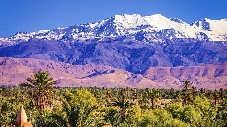
The High Atlas, the most prominent section, contains the highest peak in North Africa—Mount Toubkal, which rises to 4,167 meters. The Middle Atlas lies to the north and is known for its forested plateaus and cooler climate. The Anti-Atlas stretches toward the southwest, gradually merging into desert landscapes. This arrangement is easily traced when examining a map of morocco atlas mountains, where elevation changes and ridge lines clearly define the terrain.
Topographic Features and ElevationOne of the most important features visible on a map of morocco atlas mountains is the dramatic variation in elevation. The Atlas Mountains are characterized by steep valleys, deep gorges, and high plateaus. These topographic differences create natural barriers that have historically influenced transportation and communication routes across Morocco.
The High Atlas region dominates the central part of the system, with snow-capped peaks visible during the winter months. In contrast, the Middle Atlas is less rugged but still elevated, featuring volcanic plateaus and rolling hills. The Anti-Atlas is older geologically and more eroded, resulting in lower, rocky formations.
When viewed on a map of morocco atlas mountains, contour lines and shading emphasize these elevation differences, helping to illustrate how the mountains shape regional geography.
Climate Influence and Natural EnvironmentThe Atlas Mountains play a crucial role in shaping Morocco’s climate, and this influence is clearly understood when analyzing a map of morocco atlas mountains. The range acts as a natural barrier between the humid coastal regions and the dry Sahara Desert.
Moist air from the Atlantic Ocean is forced upward by the mountains, causing rainfall on the western slopes. This results in fertile valleys and forests in certain areas of the Middle Atlas. On the eastern side, however, the climate becomes significantly drier, leading to semi-arid and desert-like conditions.
The variation in climate zones across the range supports diverse ecosystems. Cedar forests, alpine meadows, and desert shrubs can all be found within relatively short distances. A morocco atlas mountains helps visualize how these ecological zones are distributed according to elevation and orientation.
Human Settlement and Cultural ImportanceHuman settlements in Morocco are deeply influenced by the Atlas Mountains. On a atlas mountains, villages and towns are often seen clustered in valleys and lower slopes where water resources are more accessible.
The Berber (Amazigh) communities have historically inhabited these mountain regions, developing unique architectural styles and agricultural practices adapted to the rugged terrain. Terraced farming is common in the High Atlas, where limited flat land requires creative land use.
The mountains have also served as natural protection for communities, preserving cultural traditions that differ from those in urban coastal areas. When observing a atlas mountains, it becomes clear that population density is lower in high-altitude regions compared to plains and coastal zones.
Transportation and AccessibilityThe Atlas Mountains significantly impact transportation networks in Morocco. Roads and highways must navigate steep passes and winding valleys, making travel between northern and southern regions more complex.
On a map of morocco atlas mountains, major routes often appear to cut through mountain gaps or follow river valleys. The Tizi n’Tichka Pass in the High Atlas is one of the most important mountain crossings, connecting Marrakech with the southern regions.
These transportation challenges have historically isolated certain communities, but modern infrastructure has improved accessibility. Still, the rugged terrain remains a defining feature visible on any atlas mountains.
Tourism and Economic SignificanceTourism is one of the most important economic activities associated with the Atlas Mountains. Visitors are drawn to hiking trails, ski resorts, traditional villages, and dramatic landscapes.
In the Atlas Mountains, popular destinations such as Mount Toubkal, Oukaïmeden ski resort, and the Todra Gorge are key highlights. These areas attract trekkers, climbers, and cultural tourists seeking authentic mountain experiences.
The tourism industry has helped support local economies, especially in remote Berber villages. Guided tours, guesthouses, and artisan crafts are common sources of income. The visual representation of these locations on an Atlas Mountains shows how tourism is concentrated in specific accessible zones.
Geological Formation and Natural HistoryThe Atlas Mountains were formed millions of years ago through tectonic activity associated with the collision of the African and Eurasian plates. This geological history explains their complex structure and varying elevations.
When studying a map of Morocco's Atlas Mountains, the alignment of ridges and valleys reflects this long process of uplift and erosion. The Anti-Atlas is the oldest section, while the High Atlas is geologically younger and more elevated.
Fossils and sedimentary layers found in the region provide evidence of ancient marine environments, indicating that parts of the range were once underwater. This deep geological history adds another layer of significance when interpreting a atlas mountains.
ConclusionThe Atlas Mountains are a defining feature of Morocco’s physical and cultural landscape. From their towering peaks to their deep valleys, they shape climate, settlement, and economic activity across the country. A map of morocco atlas mountains reveals not only the physical structure of the region but also the complex relationships between geography and human life.
By studying the mountain system through maps, one gains a clearer understanding of how natural formations influence national identity, environmental diversity, and regional development. The Atlas Mountains remain one of the most important geographical landmarks in North Africa, continuously shaping the story of Morocco.
Private Chef Sunshine Coast: A Luxury Dining Experience at Your Home
Private Chef Sunshine Coast: A Luxury Dining Experience at Your Home
Orthopedic Shoe Store Near Me: Finding the Right Footwear for Comfort...
Orthopedic Shoe Store Near Me: Finding the Right Footwear for Comfort and Support
Electric Gate Perth: Enhancing Security and Convenience for Modern Pro...
Electric Gate Perth: Enhancing Security and Convenience for Modern Properties
Understanding Transformer Components and Low Voltage Transformers in t...
Czy automaty online mogą być bardziej lukratywne niż w kasynach stacjo...
Czy automaty online mogą być bardziej lukratywne niż w kasynach stacjonarnych?